New images document the re-emergence of Tulare Lake, and residents brace for more flooding as snowpack starts to melt
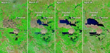
New satellite images released from Nasa this week showcase the dramatic reappearance of California’s Tulare Lake after water swallowed swaths of land across the state’s agricultural center that had long been dry.
Taken between the start of February and the end of April and colored artificially to help distinguish the water from vegetation and bare ground, the images highlight the scale of the transformation across the region still grappling with the aftermath of this winter’s heavy rains and snow.
This isn’t the first time the “ghost lake” has caused widespread flooding, but the onslaught of weather whiplash wreaked havoc on residents, agricultural workers and farms – and it’s far from finished.
Tucked against the Sierra Nevada’s white-capped peaks, the region will have to reckon with surges of snowmelt filling its waterways as the weather warms. On Thursday, the snowpack in the southern Sierra was 436% of normal for this time of year, according to California’s department of water resources (DWR).
“This year’s massive snowpack is posing continued flood risks in the San Joaquin Valley,” said the DWR director, Karla Nemeth, in a written statement, noting the bittersweet outcome of very wet winter after years of drought.
The snowpack will lead to sustained high flows across the San Joaquin and Tulare basins over several months, Nemeth said.
Widespread damage has already been done. The rapidly rising waters forced evacuations across the region in early spring, as communities rushed to higher ground. In Tulare county – one of the world’s largest milk-producing regions – thousands of cows were lost to the floods, while roughly 75,000 had to be trailered to safety. Growers were washed out of key crops and workers lost out on jobs across the waterlogged valley.

Nasa satellite images show the progression of flooding in the Tulare Lake basin. Photograph: Nasa
Decades have passed since Tulare – once the largest body of fresh water in the west – served as a vibrant wetland sprawling across nearly 800 sq miles. Carved up with canals and cleared for the cropland and livestock pastures in the late 19th and early 20th centuries, the basin now spans across multiple counties and is home to roughly 4 million Californians.
About half a dozen towns remain at risk from flooding, including Corcoran, where city officials are rushing to raise a sinking levee before the waters rise further. Stretching across 14.5 miles, the levee protects against flood waters up to 188ft. In March, Tulare Lake levels crept close, rising to 178ft.
“The Corcoran community only has a small window of time and dry conditions before the Sierra Nevada Mountain Range snowmelt runoff converges with existing floodwaters in the Tulare Lake, and against the Corcoran Levee,” emergency officials warned in a press release in April, noting that requests for state and federal funding had been made.
Source: The Guardian